1 of 2 tropical waves could threaten Bahamas as Hurricane Gabrielle churns in Atlantic, the NHC says
Published in News & Features
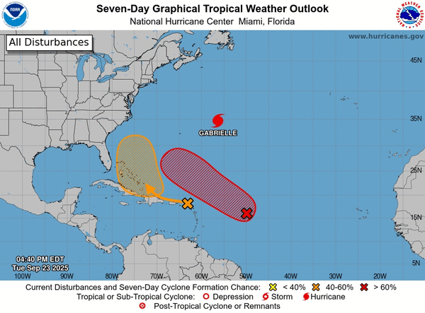
With the tropics stirring up a busy Tuesday, the National Hurricane Center said one of two developing Atlantic systems could become a tropical depression near the Bahamas this week.
The NHC was also eyeing a second tropical wave with an even higher chance to develop, as well as Category 4 major Hurricane Gabrielle that swept past Bermuda and has headed back into the open Atlantic.
As of the NHC’s 2 p.m. EDT tropical outlook, the closest of the systems to Florida was a tropical wave labeled Invest 94L that has a moderate chance of developing, with a large area of disorganized showers and thunderstorms already producing stormy conditions across the Caribbean’s Windward and Leeward Islands.
“This wave is expected to move west-northwestward at 15 to 20 mph, spreading heavy rainfall and gusty winds into Puerto Rico and the Virgin Islands tonight and Wednesday,” forecasters said.
“The system is then expected to slow down and turn northwestward when it reaches the southwestern Atlantic near the Bahamas late this week, and a tropical depression could form when the disturbance is in that region.”
The NHC warned interests in the Virgin Islands, Puerto Rico, the Turks and Caicos Islands and the Bahamas should monitor the system’s progress.
The NHC gave it a 20% chance to develop in the next two days, and 60% in the next seven.
The National Weather Service in Melbourne said it’s too early to tell if the system will be any threat to Florida aside from poor beach and boating conditions.
“The tropics are becoming more active with multiple disturbances to monitor,” the NWS stated. “It is a good reminder that we are in the peak of hurricane season and to have an emergency plan in place. Residents and visitors should continue to monitor the forecast for updates.”
The second tropical wave, labeled Invest 93L, has higher chance to develop, located in the central tropical Atlantic a little less than 1,000 miles east of the Caribbean’s Lesser Antilles with shower and thunderstorm activity that continued to become more organized.
“Environmental conditions are forecast to be generally favorable for development, and a tropical depression is likely to form during the next couple of days while the system moves west-northwestward to northwestward into the western tropical Atlantic,” forecasters said.
The NHC gave it a 60% chance to develop in the next two days and 90% in the next seven.
If either tropical wave were to grow into a named storm, it could become Tropical Storm Humberto, leaving Imelda as the next name on the 2025 Atlantic hurricane list.
As for Hurricane Gabrielle, which grew from a tropical storm on Sunday and rapidly intensified into a Category 4 hurricane by Monday, it has kept its strength into Tuesday.
As of the NHC’s 5 a.m. advisory, the storm still had 140 mph sustained winds located about 305 miles east-northeast of Bermuda and 1,855 miles west of the Azores headed northeast at 13 mph.
Hurricane-force winds extend out 40 miles while tropical-storm-force winds extend out 140 miles from its center.
“A faster northeastward to east-northeastward motion is expected through Thursday. On the forecast track, the center of Gabrielle will continue to move away from Bermuda today,” forecasters said.
Projections have it dropping from its Category 4 major hurricane status later Tuesday, then dying back down as its path continues east into the open Atlantic.
“Gabrielle is forecast to approach the Azores late on Thursday. Interests in the Azores should monitor the progress of Gabrielle, though. It is too soon to specify the magnitude of potential wind, rainfall and wave impacts,” forecasters said.
The NHC also warned swells from the system will continue to slam into Bermuda and the U.S. East Coast from North Carolina northward, including Atlantic Canada, with potential life-threatening surf and rip conditions.
The climatological peak of the Atlantic hurricane season was on Sept. 10, but 60% of annual activity has historically happened after this date, the NHC stated.
The only other hurricane this season had been Hurricane Erin, which grew into a massive Category 5 system with 160 mph winds but remained in the Atlantic without making landfall.
The National Oceanic and Atmospheric Administration in early August updated its season forecast to call for 13-18 named storms this year, of which five to nine would grow into hurricanes. Two to five of those would develop into major hurricanes of Category 3 or higher.
Hurricane season runs from June 1 to Nov. 30.
_____
©2025 Orlando Sentinel. Visit orlandosentinel.com. Distributed by Tribune Content Agency, LLC.


Comments