Hurricane Gabrielle shows no change but Atlantic systems increase in intensity
Published in Weather News
ORLANDO, Fla. — Hurricane Gabrielle on Monday hasn’t shown change since the last update; however, two more systems the National Hurricane Center is tracking have intensified.
Gabrielle is expected to move well clear of Bermuda in the open Atlantic, but where the new systems could threaten remains in question.
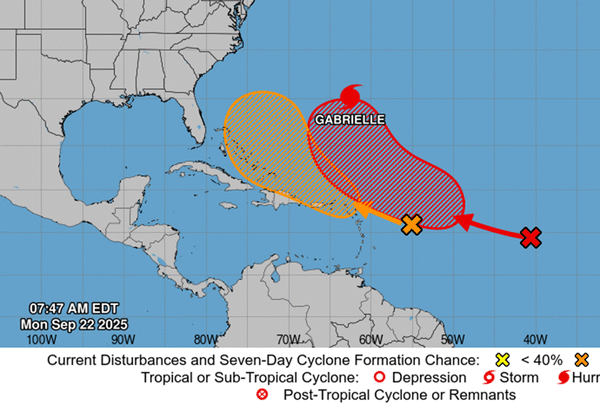
As of the NHC’s 8 a.m. tropical outlook, both of the Atlantic systems have increased in intensity. The central tropical Atlantic wave has increased with environmental conditions, making it more favorable for development by Tuesday.
“Environmental conditions are forecast to become more favorable for development by tomorrow, and a tropical depression is likely to form by the middle to latter part of this week while while the system moves west-northwestward to northwestward across the central Atlantic.,” forecasters said.
The NHC gave it a 20% chance in the next two days and 70% chance to develop in the next seven days.
A second tropical wave about 400 miles east of the Caribbean’s Lesser Antilles was producing disorganized showers and thunderstorms.
“By the latter part of this week, the system is expected to slow down and turn more northwestward, and a tropical depression could form late this week when the system is over the southwestern Atlantic Ocean or near the Bahamas,” forecasters said. “Regardless of development, gusty winds and showers are expected to affect portions of the Leeward Islands late tonight and Tuesday.”
The NHC warned gusty winds and showers would hit the Caribbean’s Leeward Islands on Monday night and Tuesday whether it develops or not.
The NHC gave it a 10% chance to develop in the next two days and 40% in the next seven.
If either were to become a named storm, they could become Tropical Storm Humberto. The next name on the list would be Imelda.
As for Hurricane Gabrielle, which grew from a tropical storm on Sunday, as of the NHC’s 5 a.m. advisory Monday, the storm had intensified with 90 mph sustained winds keeping it a Category 1 hurricane. It was located about 210 miles southeast of Bermuda headed north-northwest at 10 mph.
Hurricane-force winds extend out 25 miles while tropical-storm-force winds extend out 140 miles from its center.
“A turn toward the north is forecast later today, followed by a faster northeastward or east-northeastward motion on Tuesday. On the forecast track, the center of Gabrielle is expected to pass east of Bermuda tonight,” forecasters said.
Projections have it growing into a Category 3 major hurricane by Tuesday morning with sustained winds of 120 mph, although with a path that shifts back east into the open Atlantic after passing near Bermuda.
The NHC warned swells from the system continue to threaten Bermuda with potential life-threatening surf and rip conditions. The swells will reach the U.S. East Coast from North Carolina northward and into Canada starting Sunday and continuing through early this week.
The climatological peak of the Atlantic hurricane season was on Sept. 10, but 60% of annual activity has historically happened after this date, the NHC stated.
The only other hurricane this season has been Hurricane Erin, which grew into a massive Category 5 system with 160 mph winds but remained in the Atlantic without making landfall.
The National Oceanic and Atmospheric Administration in early August updated its season forecast to call for 13-18 named storms this year, of which five to nine would grow into hurricanes. Two to five of those would develop into major hurricanes of Category 3 or higher.
Hurricane season runs from June 1 to Nov. 30.
----------------
©2025 Orlando Sentinel. Visit at orlandosentinel.com. Distributed by Tribune Content Agency, LLC.


Comments